HISTORY
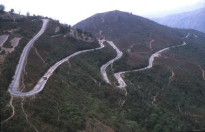
Feasibility studies for a road linking Dharan and Dhankuta began in earnest in the early 1970s. Based on interpretations of aerial photographs and topographic maps, a team of Italian consultants proposed a route based on the ‘steady climb-and-descend’ principle, i.e. avoiding banks of hairpins. The route was about 75 km long, as compared with the straight-line plan distance of 18 km.
In late 1973 the UK Government took over the project under its then Overseas Development Administration’s (ODA) aid scheme for developing countries and appointed Rendel Palmer & Tritton (RPT), consulting and designing engineers, to undertake feasibility and preliminary design studies. RPT assessed the proposed aligment and found it to be unsuitable in several aspects. A field location team was deployed after the 1974 monsoon and selected a shorter alignment of about 51 km (Road Location Map), based on strategically-located banks of hairpins to make height quickly on relatively stable ground, in preference to longer lengths of gradual climb and descent. Technical studies of the ‘RPT Alignment’ in early 1975 concluded that it was feasible. RPT continued with preparation of alignment drawings and preliminary earthworks and drainage designs. Documents were finalised in August 1975.
The ODA appointed the then Property Services Agency (PSA) as managing contractor in (month/year). Construction of the road began in (month) 1976 and was substantially completed by mid-1982. The PSA established construction camps at Shivadhara (Base Camp), Phalametar, Tamur and Guthitar and deployed up to 60 staff at any one time to manage the project, comprising civil engineers, land surveyors, quantity surveyors, inspectors of works, electrical and mechanical engineers and fitters, and senior administrative staff. RPT deployed a team of up to 10 engineers (civil, geotechnical and structural) and land surveyors to undertake detailed design of earthworks, retaining walls, drainage and bridge structures during the construction stage. Each professional grade was supplemented by direct employment of local counterparts and assistants, together with seconded staff from the Nepalese Government’s Department of Roads (DOR).
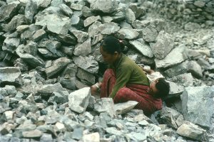
Most of the road was constructed by manual methods. The use of mechanical and other plant was restricted mainly to road surfacing operations, haulage of stone for use in gabion structures, and construction of the Tamur Bridge. Explosives were used occasionally in some of the bigger rock cuttings, but most of the earthworks, retaining structures, culverts, minor bridges and offsite protection works were excavated or built by hand, especially in the first 40km up to Guthitar.
|
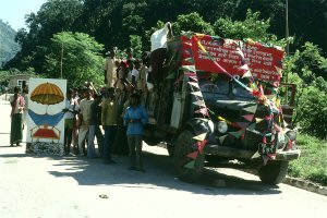
The main road-building contracts typically consisted of a few kilometers of road formation and drainage works and were tendered to local contractors. At the peak of construction in 1978-79, more than 15,000 labourers and other contract staff were employed on the project.

With continued funding from the ODA (later DFID), Roughton & Partners (later Roughton International) took up maintenance of the road in 1983 and remained in this role up to 2002. Since then the DOR has taken over maintenance of the road.
In its first 25 years of operation, the road has been seriously affected by one large earthquake and several major floods in the Leoti Khola. The earthquake, of Richter Magnitude 6.6, occurred on 21 August 1988, with an epicentre about 65 km to the west of Dharan. Over 800 people were killed in Eastern Nepal and NE India. Parts of the road were severely damaged in the earthquake and remained closed to full traffic for several months. More detailed information about the road is given in the Technical Section.
|